


Huascarán National Park
Declared "Natural World Heritage Site" and Biosphere Reserve by UNESCO
GEOGRAPHICAL LOCATION
Located in the Cordillera Blanca, Sierra Central of Peru in the Andean Department of Ancash. The park spans parts of the provinces of Recuay, Huaraz, Carhuaz, Yungay, Huaylas, Pomabamba, Mariscal Luzuriaga, Huari Corongo, Sihuas and Bolognesi. 08°50'-10°40'S, 77°07'-77°49'W
DATE AND HISTORY OF ESTABLISHMENT
The national park was established on 1 July 1975 by Supreme Decree no. 0622-75-AG (under the law on Forests and Wildlife, Decree-law No. 21147). Internationally recognized as a Biosphere Reserve under UNESCO's Man and the Biosphere program in 1977 and inscribed on the World Heritage List in 1985.
AREA
National Park and World Heritage Site 340,000ha
Biosphere Reserve 399,239ha
LAND TENURE
The majority of the park belongs to the State, although chronic confusion regarding land tenure rights and the protected area status persists. It contains five properties conceded to the SAIS Atusparia, and seven farming communities. In the 'influence zone' there is local community ownership with the northern modified zone entirely occupied by farmers, while the southern modified zone is occupied by small grazers.
ALTITUDE
2,500 m. to 6,768 m above sea level at the summit of El Huascarán (the highest peak in Peru).
PHYSICAL FEATURES
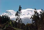
The park encloses a diversity of geomorphological features. It is situated in the Cordillera Blanca, the highest tropical mountain range in the world, with 27 snow-capped peaks above 6,000m. Some 663 glaciers, 296 lakes and 41 rivers discharge into the Santa, Pativilca and Marañón watersheds. The lowest point in the reserve is Grand Cataract, near the northern boundary. The base rock consists principally of sediments from the Upper Jurassic seas and of Cretaceous and Tertiary volcanic deposits which make up the Andean batholiths. There is still some seismic activity in the area; the last earthquake occurred in 1970, and there are three thermal springs (Castro et al., 1990).
CLIMATE
The mean annual temperature is about 3°C, the minimum being -30°C. Mean annual precipitation is approximately 884mm (recorded at 3,980m), falling mainly between October and May.
VEGETATION
The wide topographic range supports an equally wide range of vegetation types with humid montane forest in the valleys and alpine fluvial tundra, and very wet sub-alpine paramo formations at higher levels. Studies have identified 104 families, 340 genera and 799 plant species. Puya raimondii (I), a distinctive alpine bromeliad, is abundant together with other Bromeliaceae species, mountain orchids (Orchis spp., Masdevallia spp.) and relict forests of Polylepis spp. and Gynoxys spp. (Castro et al., 1990).
FAUNA
Ten mammal species have been recorded, including spectacled bear Tremarctos ornatus (V), puma Felis concolor incarum, mountain cat F. pajeros, white-tailed deer Odocoileus virginianus and the vicuna Vicugna vicugna (V) are important indigenous species, but all have been heavily hunted in the past. The North Andean huemul Hippocamelus antisensis (V), is also noteworthy. Some of the most notable bird species of the 112 that have been recorded include Gurney's buzzard Buteo poecilochrous, Andean condor Vultur gryphus, giant hummingbird Patagona gigas peruviana, giant coot Fulica gigantea, and ornate tinamou Nothoprocta ornata.
CULTURAL HERITAGE
For centuries, the Cordillera region has been the site where ethnic groups have settled, as witnessed by ruins at Gekosh and Chuchumpunta and at Willcahuain-Huyllap-Pumacayan, and Hechkap-Jonkapampa. These represent the largest known collection of such remains in the world. The most ancient cultures seem to have developed in the northern part of the park; the remains at the Cueva del Guitanero in Yungay date back 2,000 years before the Chavin culture, spreading from Carhuaz to Pomabamba. Thirty-three potentially important sites are known (L. Hamilton, pers. comm., 1994).
LOCAL HUMAN POPULATION
The Callejón de Huaylas, just outside the national park is mostly agricultural land and urban development. Grazing, plantation forestry and mining also occur. There are 74 families living within the national park, with a total population of about 349, and an additional 250,000 inhabitants within the buffer zone. The valleys are grazed by both domestic and native livestock (llama and alpaca) under an agreement with the local people (INRENA, pers. comm., 1995).
VISITORS AND VISITOR FACILITIES
The park is popular among mountaineers and there is a well developed system of trekking and mountaineering routes, probably the largest in Peru. There is a small visitor centre, hostel and campsite in the park. In 1994, the total number of paying visitors at two entrances sites was 83,240, most of whom were day visitors and 5% were foreigners (INRENA, pers. comm., 1995).
SCIENTIFIC RESEARCH AND FACILITIES
There is currently no formal research or monitoring programme although research has been conducted on the geography, glaciology, flora and fauna of the area. Accommodation in the form of refuges is available along certain lagoons and ravines. These are either managed by Electro Peru or the Ministry of Agriculture. A hostel currently used by mountaineers, will eventually be used by scientists. There is a modest two-room environmental education centre at one of the park entrances, and another is being developed. At the Querochoa entrance, a park building is being offered as a school for the children who live in the valleys. The headquarters at Huaraz is reasonablywell equipped with a computer, radio, fax and telephone and there is a herbarium with 700 species (INRENA, pers. comm., 1995).
CONSERVATION VALUE
Huascarán is the second highest park in the South American Andes and is at the centre of the highest tropical mountain range in the world. The high puna plateaux, glaciers and cluster of peaks over 6,000m make it one of the most scenic of all mountain regions.
Source:UNESCO
Location: Department of Ancash.
Area: 340,000 hectares.
Creation: July 1975.
Intangible area, protection area of regional flora and fauna, geologic formations, archaeological remains of the pre-Inca Chavín Culture, and scenic beauty of the Cordillera Blanca (White Mountain Range) formed by glaciers, snowy mountains and 630 lagoons.
Rich area in puyas of Raimondi, vicuñas (Vicugna Vicugna), tarucas - Andean deer - (Hippocamelus Antisiencis), condors (Vultur Gryphus), bears, foxes, pumas, numerous species of birds, etc.
The puya of Raimondi, is a plant with origins in Peruvian Andes, of unique characteristic in the world, one plant has 8 thousand inflorescence and 6 million seeds, and it can reach up to 10 meters (32.8 feet) height.
The park is located on the summits and high Andean area; it embraces all the territories with more than 4,000 meters above sea level of the White Mountain Range. All the entrances to the area of the park are marked with a landmark with the acronym "PNH" of orange color, you should register and pay a right when entering.
Inside the area of the park exist numerous native communities, which are under protection, they are trying to improve the level of their inhabitants' life.
In the description of the Cordillera Blanca (White Mountain Range) we detail some attractiveness of the park and here we highlight the following ones,
The Huascarán is the snowy mountain with the highest peak in the Andean mountain range of Peru, reaching a height of 6,746 meters (22,132 feet) above sea level.
Llanganuco lagoon, also called Chináncocha, beautiful lagoon formed by the thaw of the Huascarán, it is divided in two sectors. Fishing of trouts and beautiful landscapes. In its turquoise blue waters are reflected the snowy peaks of immense mountains. Beautiful view of the Valle del Santa (Santa Valley) and the Cordillera Negra (Black Mountain Range).
Parón lagoon, it is surrounded by 6 snowy peaks with more than 6,000 meters (19,685 feet) of altitude, outstanding among those the Huandoy, Aguja Nevada and the Pirámide Garcilaso. Natural landscape of indescribable beauty.
Other beautiful lagoons in the park are, Pelagatos, Púsac Cochas (8 lagoons), "Chica de Santa Cruz" lagoon and "Grande de Santa Cruz".