Nazca Lines |
Nazca Lines |

Cahuachi |

Chauchilla |
Cantayoc |
Paredones |
 Nazca Lines |
Archaeological Places in Nazca
Nazca Lines
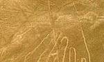
Some of the world’s most famous geoglyphs can be seen in the arid San José plains on the southern bank of the Ingenio river. On the barren, dry plain, the Nazcas, but also more recent occupants, carved geometric figures and animal silhouettes in a gigantic scale that has not been replicated elsewhere on Earth.
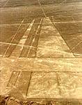
Palpa Lines and Figures
Kilometer marker 400 of the South Pan-American Highway. These are enormous zoomorphic and phytomorphic geometric drawings similar to the Nasca Lines. They are located in the towns of Sacramento, Pinchango, and Llipata.
Archaeological places to north of Nazca City
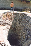
Aqueducts of Nazca (Puquios) - Cantayoc
4 Km / 2 miles from Nazca (15 minutes). Archaeological remains of the Nazca culture, it shows the high development reached in hydraulic engineering, complex of underground aqueducts and reservoirs.
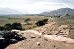
Paredones
Kilometer marker 1 of the Nasca-Puquio Highway (5 minutes from Nazca). It is an archaeological site that probably was an Inca administrative center. Formed by numerous rooms, terraces, and patios, its buildings have stone foundations and adobe walls.
Archaeological places to south of Nazca City
The Cahuachi ceremonial center
Nazca (200 BC-900 AD) is the name of one of the most famous pre-Columbian Andean civilizations. Reputed around the whole world for its fine pottery and for the enigmatic lines and figures drawn in the Palpa and San José plains, this culture saw its first development in the Rio Grande basin, about 400 km south of Lima and many kilometers away from the sea. Cahuachi spreads over 150 Ha of arid hills and dunes.
Estaquería
Archaeological complex of the Nazca culture, solar observatory, on platforms made of adobes and columns of "huarangos" trunks (variety of tree). This archaeological complex is near to Cahuachi.
Chauchilla
Pre-Inca cemetery, in which the profanation of tombs by the huaqueros, have left open some tombs in which you can appreciate the old inhabitants' remains. It is located at 28 km (17.4 miles) to the south of Nazca.
DEFEATING THE DESERT: THE NAZCA PUQUIOS
The Nazca valley also has evidence of large hydraulic projects. Taking advantage of the water table, which was close to the ground, the ancient Nazca developed an underground filtering gallery system, known as puquios, to irrigate the areas lacking surface water. These clever galleries, known as puquios, successfully met the challenge of hash water conditions in the valley’s middle sections, a 15 km stripe where water can only be found underground. The lack of surface water is due to the fact that the Nazca desert is regularly interrupted by small valleys made up by the driest rivers of the Pacific. Coast, which carry water only in the summer and even then irregularly. In these conditions, simple detouring canals are useless, because the river and its small tributaries torn into barren dry courses. Irrigation ditches are effective when the sloping ground can take the water where needed by simple gravity, as in the valleys of northern Peru. But in the southern valleys, where the slopes are less marked, pre- Hispanic societies found other technological answers for taking water away from its natural course and defeated the ongoing threat of desert, made even worse by the strong winds blowing in the region.
By means of series of deep wells spaced every 20 meters, Ica people reached the water table. The wells can still be seen around. They were communicated by means of a network of a network of galleries for circulating water. Careful monitoring of the ditches’ inclination and lining them with stones to minimize leaks allowed to bring water to the surface to finally store it in circular reservoirs or qochas, from which it was transported to the fields by canals. To date, 35 puquios have been identified, many of them still in use. Numerous galleries covered with boulders and roofed with large stone slabs and huarango tree (Acacia machracanta) branches are still seen in the area. Also, every 10 to 20 meters vents permitted air circulation and the periodical cleaning of the galleries. These were often built at more than 10 meters of depth over an average length of 500 meters. An exceptionally long gallery however reaches.